About the Salt Line
 The Salt Line lies just south of Sandbach (M6 junction 17) and is a 3km / 1.8 mile route following the line of a disused railway, of which 2.5 km / 1.5 miles is a well surfaced trail.
Mostly flat and in some parts raised on embankments, it cuts through farmland and woodland as it runs towards Alsager.
The Salt Line is mostly wooded along its length and is interspersed with areas managed as open glades and coppice.
About Borrow Pit Meadows
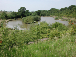
The Borrow Pit Meadows near Alsager is adjacent to the Salt Line and both sites are linked by access points and paths. The Borrow Pit Meadows are about 16 hectares / 40 acres in size with 2kms / 1.25 miles of well surfaced undulating paths, with a further 1km / 0.6 miles of unsurfaced paths.
It is a mosaic of habitats including meadows, woodland, wetland, grassland, farmland and scrub. With benches located at regular points along the surfaced routes, it is ideal for quiet recreation on foot or bike and will also be of interest for those who enjoy birds, plants, trees and wildlife.
PDF accessibility
The PDF documents on this page may not be fully accessible to screen reader technology due to the map content. If you require them in an alternative format please email webteam@cheshireeast.gov.uk.
Page last reviewed: 15 August 2022
Thank you for your feedback.