Cheshire's Changing Boundaries
The boundaries of Cheshire have changed over the last thirty years as the area has developed.
We have reviewed town and parish council governance arrangements across the Cheshire East Borough. You can find further information on our Community governance review page.
To find out if an address is in Cheshire East - see find your local council (GOV.UK)
Cheshire before 1974
At the time Cheshire included the Wirral in the west of the County and places such as Stockport, Hyde, Stalybridge, Cheadle, Bramhall and Altrincham in the northeast of the County. The Manchester Ship Canal and River Mersey defined the boundary between Cheshire and Lancashire.
Cheshire from 1974 to 1998
Local government was re-organised in 1974 and many boundaries were redrawn. The Wirral became a metropolitan borough in Merseyside. Many places in the northeast of the county also became Metropolitan boroughs within Greater Manchester. However Runcorn and Widnes became parts of Halton Borough Council. Warrington and Halton became borough councils in Cheshire.

Cheshire from 1998 to 2009
In April 1998, Warrington and Halton (which covers Widnes and Runcorn) became unitary councils separate from the administrative county of Cheshire in terms of local government service provision. Cheshire covered Neston in the west to Disley in the northeast, Alsager in the southeast, and from Audlem and Malpas in the south to High Legh and Frodsham in the north.

Cheshire Today
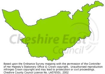
Cheshire's administrative boundaries changed again in April 2009. Cheshire County Council and its constituent district and borough councils were superseded by Cheshire West and Chester Council and Cheshire East Council. Cheshire East is the third largest council in the North West stretching from Audlem in the south to Disley and Poynton in the North, it has a population of over 360,000 people.

Page last reviewed: 13 June 2024
Thank you for your feedback.