Maw Green Road flooding
What you need to know
Maw Green Road passes beneath a railway bridge leading into Crewe and has experienced flooding at least 3 times in the past 5 years. Our Lead Local Flood Authority has identified the cause of flooding as a combination of surface water and water from the Fowle Brook. When flooding occurs, the road may need to be temporarily closed and cause disruption for residents, commuters, and local businesses.
Understanding the causes
Flooding at this location is caused by a combination of factors:
- Heavy rainfall and surface water runoff
- High water levels in Fowle Brook (a nearby main river)
- A drainage system located in a difficult-to-access area between a landfill site and railway tracks
Although the drainage system usually works as intended, problems can occur when the water levels in the Fowle Brook rise. This can limit flow out of the underpass, causing water to build up and flood the road.
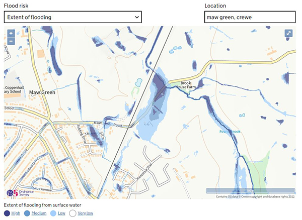
The map below extract from the website Check your long-term flood risk (opens in a new window). It shows the yearly chance of flooding from surface water in and around Maw Green Road.
What we've done
We've taken several steps:
- A feasibility study has been undertaken to identify potential solutions.
- The council have engaged with the Environment Agency about undertaking remedial works on Fowle Brook, and they have significant concerns, meaning it cannot easily be undertaken .
- Installed "road liable to flooding" signs to warn motorists of the potential hazard of flooding.
- Worked with a local housing developer to install boundary drainage to reduce surface water runoff entering the highway.
- Fixed ineffective gullies on Maw Green Road.
- Explored funding options, but a viable business case is currently unavailable.
Future action
Further improvements to the highway drainage system may help reduce how often flooding happens, or how severe it is. However, these improvements depend on being able to discharge water into Fowle Brook effectively.
At present:
- Required works to the brook are complex and expensive
- No external funding is available to support large-scale improvements
- We will continue to review opportunities as they arise.
Our role and responsibilities
Cheshire East Council is committed to managing flood risk and keeping roads safe. We meet our Highway responsibilities by:
- Installing warning signs to protect road users
- Acting as the Lead Local Flood Authority under the Highways Act 1980
In addition, we investigate all reports of flooding that affect homes, businesses, communities, and essential infrastructure across Cheshire East.
When a flooding event has a significant impact, the Lead Local Flood Authority (LLFA) will carry out a formal flood investigation, known as a Section 19 (S19) investigation.
The investigations that have been published can be found here: Flood Incident Investigations and Reports.
What you can do
Flooding can affect different areas in different ways, so it’s important to understand your own level of risk. Taking small steps now can help reduce the impact of flooding in the future.
We encourage you to:
Responsibilities for managing rivers and watercourses
For more details please see guidance owning a watercourse (opens in a new window).
Further advice on the council's approach to managing these watercourses can also be found on the Flood risk management page.
Page last reviewed: 23 July 2026
Thank you for your feedback.