Macclesfield Road, Rainow - embankment and carriageway collapse
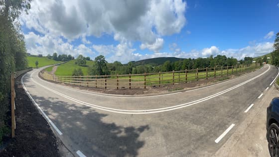
The embankment supporting the B5470 Macclesfield, midway between Ginclough and Kettleshulme collapsed together with part of carriageway in January 2025.

Before the road collapse, temporary traffic lights were in place for safety reasons to mitigate the risk to the public while we investigated defects found on the embankment. We consider significant rainfall to have been a contributory factor to the sudden subsidence, which was unexpected.

The road remains closed for safety reasons.

What is happening

The work started on 27 October 2025, and it was expected to take approximately 20 weeks to complete.

We carried out the work over winter so we could see the issues on site at their worst. During excavation on both sides of the embankment, we found long‑standing and previously hidden defects that must be repaired before the road can reopen safely. Recent snow, storms and persistent wet weather have also slowed progress.

Because of these extra issues, more work is needed to make sure the road is safe and stable for the long term. This means the construction programme will take longer than planned, and we now expect the road to reopen in early summer 2026.

Our teams are reviewing the programme to reduce delays as much as possible, and we will share a more detailed update as soon as we can.

We understand the disruption this causes and are working hard to complete the repairs and reopen the road safely and quickly. Thank you for your patience and understanding, and we apologise for any inconvenience caused during these essential works.

The works taking place include:

  • a reinforced earth slope will be built with a green face that’s hydroseeded to blend into the natural surroundings
  • full replacement of the existing highway drainage system
  • covering a wider areas than just embankment collapse to provide the future stability of the road

We continue to be in close communication with the Peak District National Park Authority to ensure we meet planning and environmental regulations.

We understand that working in the Peak District during the winter is not ideal due to the weather. However, we have decided to proceed with the work to get the road reopened as soon as possible rather than delaying construction until 2026.

Throughout the construction phase, a dedicated walkway away from the works area has been provided to ensure that access for pedestrians and cyclists is maintained.

A huge amount of work has gone into ensuring the most suitable solution for the embankment repair, that also complements the natural surroundings. With everything now in place, we're ready to begin — Councillor Mark Goldsmith explains more in the video below.


Buses will be operating a revised route during the closure, see the timetable changes to the 60 and 60A bus for more information.

We appreciate that the closure causes significant detours for regular users of the road, and we apologise for this inconvenience.

Map of Macclesfield Road Rainow

Diversion route

There is a signed diversion in place and members of the travelling public, including cyclists are advised to follow this. See the full diversion route.

This diversion route is on our gritting route. You can view all of our gritting routes using our interactive map: winter treatment network. The black lines show our gritting routes.

Further information:

  • Emergency access will not be maintained due to the condition of the embankment and carriageway
  • Emergency services are aware of the closure and the diversion arrangements are in place emergency vehicles
  • The road closure is necessary to protect the safety of both members of the public and our workforce
  • Diversion routes are in place and signed
  • Local businesses remain open and access will be facilitated where possible via diversion routes
  • Delays are expected and motorists should plan journeys
  • Pedestrian and cyclist access will be maintained where possible and safe to do so

Progress update

  • Installed a temporary footbridge to allow for pedestrian and cyclist access.
  • The initial excavation was complete ahead of schedule.
  • During excavation works, we discovered an unexpected water flow and several unchartered land drains through the embankment, requiring a larger excavation and revised design to manage it. Works to address these issues are near to completion. So far, almost 2,000 tonnes of spoil has been removed and recycled.
  • Weatherproof sheeting has now been removed following the Christmas and New Year break.
  • The geotechnical membrane has been delivered and will shortly be lifted into place with a crane, to allow the reconstruction to take place.
  • Final design will deliver a vegetated finish to blend in with the landscape.
Image of collapsed embankment Rainow Road
Embankment collapse.
Footway to the new temporary bridge
Footway to the new temporary bridge.
Removal of the existing carriageway surface
Removal of the existing carriageway surface.
Rainow-cut-away-road-500x375px
Excavation of the embankment.
Protecting the watercourse
Protecting the watercourse.
The embankment covered in protective membrane
The embankment covered in protective membrane.
Craning the ballast into position
Craning the ballast into position.
The depth of the excavations
The depth of the excavations.
The land drain which has been discovered
The land drain which has been discovered.

Page last reviewed: 02 February 2026