Policy ENV 1: Ecological network
- The ecological network consists of core areas; corridors and stepping stones; restoration areas; sustainable land use areas; and the Meres and Mosses catchments (buffer zones).
- Core areas; corridors and stepping stones; restoration areas; and the Meres and Mosses catchments (buffer zones) are shown on the adopted policies map.
- Sustainable land use areas consist of all land outside of the core areas; corridors and stepping stones; and restoration areas.
- Within the components of the ecological network, as identified on the policies map, development proposals should:
- increase the size, quality or quantity of priority habitat within core areas, corridors or stepping stones;
- within corridors and stepping stones, improve the connectivity of habitats for the movement of mobile species;
- in restoration areas, improve the structural connectivity, resilience and function of the network;
- in buffer zones within core areas and around protected meres and mosses, minimise adverse impacts from pollution and disturbance.
- Areas of ecological value may be designated within neighbourhood plans and where relevant, policies for them within neighbourhood plans will also be applied when considering planning applications that might affect them.
Supporting information
4.3 LPS Policy SE 3 'Biodiversity and geodiversity' seeks to protect and enhance biodiversity and geodiversity. LPS Policy SE 6 'Green infrastructure' supports the protection, enhancement, creation and management of a network of green infrastructure. It also seeks to deliver a network of green spaces providing a variety of benefits including biodiversity (Criterion 3(x)). Policy ENV 1 seeks to deliver benefits for biodiversity from development. The policy does not seek to stifle or preclude development but seeks to secure ecological enhancement. The policy will be applied on a case by case basis so that proportional enhancement is sought.
4.4 The Natural Environment and Rural Communities Act (NERC) 2006 places a duty on every public authority, in exercising its functions, to have regard to the purpose of conserving biodiversity, so far as is consistent with the proper exercise of those functions.
4.5 The council has produced an ecological network map for the borough, which incorporates existing protected sites and priority habitats and identifies areas to restore and buffer the network. The ecological network will assist in the provision of nature conservation and ecosystem services that are essential for sustainable development, including water management, carbon capture and access to nature with associated recreational and health benefits.
Figure 4.1 Ecological network in Cheshire East
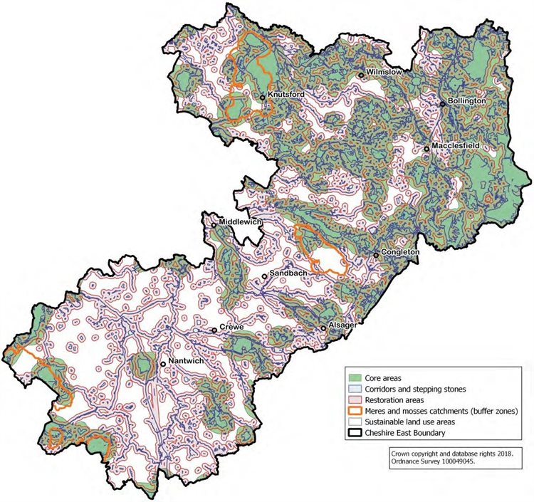
4.6 Core areas contain concentrations of habitats that are rare or important because of the wildlife they support and areas of irreplaceable natural habitat such as ancient woodland, glacial meres and peatlands, which are impossible to re-create. They include protected wildlife sites: special areas of conservation (SAC), special protection areas (SPA), Ramsar sites, sites of special scientific interest (SSSI), local nature reserves (LNR), local wildlife sites (LWS) and UK priority habitats. Buffer zones are incorporated into the core areas and protect the individual sites and habitats from external adverse impacts such as pollution and disturbance.
4.7 Corridors and stepping stones enable mobile species to move between core areas and the wider landscape. Connectivity does not necessarily mean linear continuous habitats. They could be in the form of a number of small sites acting as stepping stones and could include non-statutory sites and priority habitats outside core areas, as well as more recognisable watercourses and canals. They include SSSI (geological), Wildlife Trust sites outside core areas, the national inventory of woodland and trees, rivers, canals, English Woodland grant scheme new planting and ‘natural’ green infrastructure typologies.
4.8 Restoration areas are designed to enhance connectivity, resilience and the functioning of the ecological network. Sustainable land use areas are those within the wider landscape, focused on the sustainable use of natural resources and appropriate economic activities that assist in the delivery of ecosystem services.
4.9 Neighbourhood plans may also include policies to protect and enhance biodiversity, including through the designation of wildlife corridors. These policies, where relevant, will need to be applied to development schemes alongside the policies in the local plan. Local wildlife corridors refine and compliment the wider ecological network.
Related documents
Policy information
Previous page: Policy GEN 7 'Recovery of planning obligations reduced on viability grounds' | Cheshire East Local Plan policy index | Next page: Policy ENV 2 'Ecological implementation'