The Gritstone Trail
Temporary path closure on the Gritstone Trail
A section of the Gritstone Trail is temporarily closed due to an unsafe bridge. This affects the footpath leading from East Lodge, Lyme Park, heading northeast towards Mudhurst Lane, Disley and affects both the Trail through Lyme Park and the alternative route if Lyme Park east gate is closed. The closure is between points 2 and 3 on the map within The Gritstone Trail (PDF, 3.7MB) leaflet.
An alternative route is available via Lyme Park during park opening hours, with thanks to the National Trust. The route is shown on the Gritstone Trail Diversion Plan (PDF, 420KB).
Follow:
- Red Lane (Disley Footpath No. 75) to Red Lane Lodge
- Green Drive across Cage Hill towards Lyme House
- The Gritstone Trail to Bow Stones
Park opening hours are normally 8.30am to 8pm in summer and 8.30am to 5pm in winter. Check National Trust for details or changes.
Take extra care when planning your walk as not all roads have pavements or verges.
Thank you for your understanding.
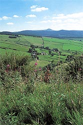 Stride out along the Gritstone Trail and sample some of the finest walking in Cheshire. This is a more challenging route stretching from Disley to Kidsgrove, with some fine ridge walks and stunning views over the Cheshire plain.
The trail is called the Gritstone Trail because of the local rock type which is millstone grit. Millstone grit is made of sand particles, grit particles and small stones, which over time built up into layers of gritstone. Millstone grit is estimated to be around 300 million years old.
The Gritstone Trail, which now includes the former Mow Cop Trail, has been extended to make it more accessible by public transport. The route is split into three sections, which can each be walked in a day by fairly fit walkers. There are few facilities along the Trail - most pubs, Café and shops are a short distance away.
Check opening times and always take some food and plenty to drink with you. Even in the summer the weather can change quickly, so always be prepared with extra layers and waterproofs.
The trail is well marked using a mixture of finger posts and yellow waymark discs with a 'G' in a footprint. Waymarks indicate the way to go as you stand directly in front of them. Often there is a clear path on the ground, but some paths may not be quite so obvious. Look out for stiles or kissing gate in hedges, fences or walls or waymark posts to guide you.
After walking the Gritstone Trail you might want to consider walking the Sandstone Trail in Cheshire West and Chester. More information about the Sandstone Trail and Cheshire’s sandstone ridge can be found at www.sandstoneridge.org.uk
When out in the countryside
- Follow The Countryside Code, keep to the path across farmland, and leave all gates as you find them. Dogs should be kept under control so they are not a nuisance to other path users, farm animals or wildlife.
- Paths may be wet and muddy at any time of year, find out What to expect.
- Although the trail is well waymarked, you are strongly advised to use the Ordnance Survey Explorer map 268, Wilmslow, Macclesfield and Congleton, and the Outdoor Leisure Dark Peak map
- The trail uses both permissive routes and public rights of way. You should not experience any problems using the rights of way network, but if you do, please report them via the Online problem report form, 01270 686029 or email the Public Rights of way team.
Accessibility
The Trail is very hilly, with several long climbs and some steep but short ascents. The Trail is mainly stile free, with kissing gates replacing stiles in most locations. Surfaces vary along the trail but they may be rough, boggy or slippery, so sensible footwear is recommended.
How to get there
There are good rail links to Disley, Macclesfield, Congleton and Kidsgrove, as well as regular bus services to the major towns and villages.
For all passenger travel and timetable information contact Traveline through Plan your journey | Traveline or 0871 200 22 33 (charges apply).
Discover more countryside sites
See all our countryside sites
Page last reviewed: 16 September 2025
Thank you for your feedback.